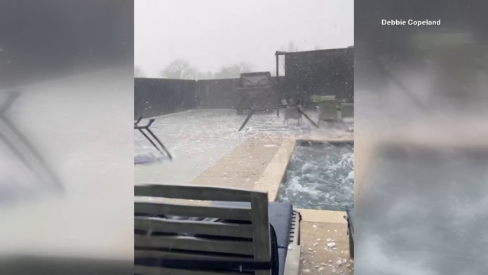
A menacing line of severe thunderstorms tore across the nation’s midsection on Wednesday, prompting emergency warnings for communities from eastern Kansas to western Missouri. The storms brought a barrage of wind, torrential rain and, most alarmingly, hail the size of baseballs that weather forecasters grimly dubbed “gorilla hail.”
As the ominous storm system advanced, the National Weather Service issued dire alerts, imploring residents to immediately seek shelter away from windows. If you are in this warning, get away from windows and shelter inside now!!!” the agency urged in an online warning, employing multiple exclamation points to convey the seriousness of the threat.
Sports ball-sized hail pounds cars in Kansas City area
Video footage from the Kansas City metropolitan area showed roadways blanketed with hailstones larger than golf balls after the storm passed through. Vehicles were dented and windshields shattered by the freezing projectiles. One amateur video depicted a torrent of baseball-sized ice chunks ricocheting off parked cars with frightening force.
“When you get up to tennis ball, baseball-sized or God forbid softball-sized [hail], that can do a tremendous amount of damage,” said Alex Sosnowski, a senior meteorologist at AccuWeather. “If you get hit in the head, that could be fatal.”
Mr. Sosnowski said the “gorilla hail” descriptor, coined by the extreme storm chaser Reed Timmer, vividly captures the ferocious power of hailstones of such an immense magnitude. He advised anyone in the path of these storms to promptly secure their vehicles under cover to avoid disastrous damage.
While hail the size of quarters or golf balls is not extraordinarily rare during harsh Midwestern thunderstorms, the potential for softball-sized frozen precipitation on Wednesday was exceptional, meteorologists said. Hail develops when powerful updrafts within thunderstorm clouds repeatedly cycle water droplets up and down, allowing them to be coated in successive layers of ice.
Storm leaves trail of destruction in Kansas and Missouri
In addition to the oversized hail, the storm system spawned multiple tornadic circulations that touched down across eastern Kansas and western Missouri, though information on specific tornado tracks and intensity was still limited in the immediate aftermath.
High winds shredded trees and downed power lines in many communities. In Branson, Missouri, a popular tourist destination known for its live entertainment shows, video showed a wind gust violently ripping away part of the roof structure at the Dolly Parton’s Stampede dinner theater.
To the north in Kansas City, strong winds toppled tractor-trailers along the area’s main interstate highway, Interstate 70, temporarily blocking travel. The highway patrol shut down a stretch of the highway due to the hazardous conditions from the high winds and hail.
Serious flash flood threat looms
While the most acute hail danger had passed by late Wednesday night, forecasters warned that the storm system would continue inundating a broad region stretching from Louisiana to Illinois with exceptionally heavy rains over the next 24 to 48 hours. Total rainfall amounts of 4 to 8 inches were projected across the central Mississippi Valley before the soggy weather finally tapered off.
“The biggest threat now is the potential for flash flooding,” said Marlene Hickok, a hydrologist at the Arkansas River Forecast Center. “With that amount of rainfall over such a large area in a short period, we could see very serious flooding develop with limited warning time.”
Residents were urged to closely monitor news and weather reports and be prepared to quickly evacuate low-lying areas if flash flood warnings were issued for their location. The threat of additional severe thunderstorms spawning tornados would also remain a danger through Thursday night across parts of Arkansas, western Tennessee and northeastern Texas, forecasters said.
While late season severe weather events like this are not unprecedented for areas such as Kansas, Missouri and Arkansas, there are concerns that storms of this intensity are becoming more frequent as the warming climate provides more fuel for explosive thunderstorm development.
Peter Sousounis, the director of meteorological research at the University of Tulsa, noted that Wednesday’s event exhibited many of the hallmarks of a rapidly intensifying springtime storm system. “We had exceptional wind shear, very moist air being pulled in from the Gulf, and highly unstable atmospheric conditions––the perfect ingredients for violent thunderstorms to form and quickly organize into a potent severe weather outbreak,” he said.
Mr. Sousounis pointed to recent studies suggesting a link between human-caused climate change and an increased frequency of such high-risk setups in the nation’s interior. “These were often once-in-a-decade types of events,” he said. “But the warming climate appears to be creating an environment where the conditions for explosive storm development may be occurring more regularly.”
While climate trends contribute to severe weather risk, Mr. Sousounis added that further analysis would be required to confirm any direct connection between climate change and the specific “gorilla hail” event this week in the nation’s heartland. For the moment, communities in the Midwest were simply focused on recovering from the onslaught of destructive hail and bracing for potential flooding in the storm’s wake.


