
Still reeling from the devastating impacts of Hurricanes Ian and Nicole earlier this autumn, Florida is now bracing for yet another barrage from Mother Nature this weekend. An intensifying storm is churning in the Gulf of Mexico, poised to unleash tropical storm-force winds, torrential rainfall, and flooding across the Sunshine State.
The looming tempest threatens to exacerbate coastal erosion and undo recovery efforts in hurricane-ravaged zones still struggling to rebuild. With tornadoes also possible, state emergency officials are sounding the alarm for residents to prepare immediately and remain vigilant through this latest bout of wild weather.
Burgeoning Storm to Lash Florida with Strong Winds
A broad area of low pressure is forecast to rapidly strengthen over the warm waters of the Gulf, its central pressure plummeting as winds intensify around the developing cyclone. This emerging storm looks increasingly tropical in nature based on satellite presentation.
As the low amplifies, so too will the pressure gradient between it and dominant high pressure anchored along the Eastern Seaboard. This tightening gradient will funnel gusty northeasterly winds across the Florida Peninsula throughout the weekend.
The most powerful winds are anticipated along immediate coastal strips, where gusts could frequently reach 40-45 mph with even higher bursts possible. Battering waves and elevated water levels will accompany these onshore winds, elevating coastal flood risks.
The National Weather Service has hoisted Wind Advisories along the entire Atlantic coast from Flagler Beach south through Palm Beach County and the Fort Lauderdale-Miami corridor. Offshore, gale warnings are up for mariners with waves forecast to build over 10 feet on the open Atlantic.
Videos Show Water Missing from Tampa Bay
In fact, winds have already pushed water out of Tampa Bay and into the Gulf of Mexico ahead of the approaching storm. Normally picturesque Tampa Bay appears strangely empty in aerial footage from Friday morning, showcasing this phenomenon reminiscent of extreme low water levels typically seen during hurricanes.
When intense winds blow offshore or away from land for an extended period, water can essentially be shoved away from shore until winds eventually shift back onshore. Tampa Bay’s missing water will likely surge back as the storm’s winds change direction.
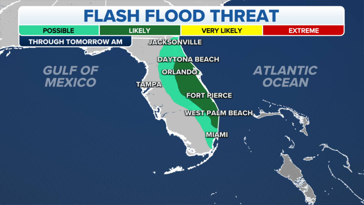
Heavy Rains Threaten Flash Flooding
While winds will clearly be impactful along the coast, torrential rainfall poses a more widespread concern inland. As the strengthening cyclone drifts north, it will tap deep tropical moisture and funnel expansive rain bands across the Florida Peninsula.
Some of the heaviest showers are forecast from Friday night into Sunday, where localized downpours could dump over half a foot of rain. This excessive rainfall presents a serious flash flood threat, especially considering Florida’s already saturated soil conditions following a rain-soaked autumn.
Flood Watches blanket most of South and Central Florida in anticipation of potential flash flooding. But the flood danger could eventually expand farther north this weekend as the heavy rain shield marches inland.
Major cities like Miami, Fort Lauderdale, West Palm Beach and even Orlando are at risk given poor drainage and overloaded storm sewer capacities—typical in urban corridors. Just three months removed from Hurricane Ian’s catastrophic flooding, the saturated ground leaves little margin for more excessive rainfall.
Of particular concern is South Florida’s heavily populated Atlantic coast, where some locations have already observed their wettest year on record, according to the National Weather Service. Single day rainfall records could topple if heaviest bands stall over the metro region. But with the storm still organizing over the Gulf, uncertainty remains regarding its eventual moisture feed into Eastern Florida.
Severe Weather & Tornadoes Also Possible
On top of prolific rainfall and blustery winds whipping the coastline, the brewing Gulf cyclone also carries a severe weather threat—especially Saturday night as it begins to pivot northward. Additional ingredients may align to produce rotating thunderstorm supercells capable of generating tornadoes after dark.
As the storm’s warm front presses north during the day, surface winds will strengthen and transport warmer, more unstable air into Central Florida by evening. With ample spin and lift in the atmosphere, thunderstorms that develop along and south of this boundary have potential to rotate. The Storm Prediction Center highlights much of the Peninsula under a Level 2 out of 5 risk for scattered severe storms.
Tornadoes often form in these highly sheared warm sectors east of strengthening low pressure centers. The zone of heightened tornado risk Saturday night looks to set up across interior Central Florida if current forecasts verify. But these supercellular spin-ups can be difficult to anticipate more than 6-12 hours in advance.
The tornado threat would gradually wane later Saturday night as the system’s cold front sweeps through, bringing drier and more stable air southward. Still, any brief tornado in overnight hours has safety implications if residents are caught sleeping.
Barrage of Impacts: Coastal Flooding, Erosion
Considering the diverse impacts expected, emergency managers have sounded alarms for Floridians to prepare now for rapidly deteriorating conditions. Multiple hazards are likely over the weekend, including:
- Coastal flooding bolstered by high winds and swell
- Severe beach erosion & dune overwash
- Thunderstorm wind gusts over 50 mph
- Flash flooding from torrential downpours
- Brief tornadoes embedded within storms
Coastal Flood Warnings cover Atlantic coastal counties from Brevard south into Palm Beach where storm surge flooding could reach 3 feet above ground, submerging many shore roads until Sunday. Powerful wave action will only exacerbate coastal flooding and erosion vulnerabilities.
Beachfront communities still repairing after Hurricane Ian just 11 weeks ago face renewed threats from coastal storm surge and damaging surf. Many protective dunes and seawalls remain compromised after the last battering—leaving limited buffers from flooding.
Considering Florida’s barrage of tropical strikes in 2022, this latest blow could further erode public and private recovery efforts. And with climatologists warning of future strengthening in storms amid global warming, coastal resilience has become an urgent priority for Florida planners.
This Weekend Storm Caps Active Hurricane Season
In an unusually busy Atlantic hurricane season, Florida took repeated hits—first from Hurricane Ian’s catastrophic storm surge and flooding on the Gulf coast in late September, followed by Hurricane Nicole’s damaging winds and coastal erosion across the central east coast in early November.
Now this late-season storm stands to hamper rebuilding initiatives and drain additional disaster aid funds. Florida Governor Ron DeSantis renewed the state of emergency declaration on December 15th in preparation for expected impacts—keeping response resources and assistance activated.
While not technically forecast to become a tropical system, the looming Gulf cyclone packs many characteristics of a weak tropical storm. Tropical storm watches were considered for Florida’s west coast given expectations for gusts near 50 mph.
Barreling toward Florida to cap a historically active hurricane season, the pre-Christmas storm is set to deliver one final round of tempestuous weather before the calendar turns.
Residents Urged to Gather Supplies, Shelter Information
Florida Division of Emergency Management Director Kevin Guthrie implored residents to take the coming threat seriously, heed local evacuation directives if given, and prepare essential items to shelter in place if necessary.
Having an established family emergency plan and disaster supply kit can significantly reduce dangers posed by power loss or temporary isolation at home. Important items to gather include flashlights, backup batteries, a first aid kit, cash reserves, battery packs to charge cell phones, and enough non-perishable foods and water to last several days.
Those living in flood-prone areas or vulnerable coastal dwellings should identify nearby shelters or family/friends offering safe harbor farther inland. Storm conditions can deteriorate rapidly, cutting off escape routes and access to provisions. Planning early is critical before winds mount and rains intensify.
Visit local emergency management agency websites for a customized hazard preparation checklist catered to your region’s anticipated impacts. Entering a valid street address generates tailored resilience advice like evacuation zones and flood vulnerabilities.
Review Weather Updates Frequently
With the Gulf storm still organizing Friday, unavoidable forecast uncertainties exist regarding its eventual track, strength and precipitation distribution. Residents are advised to frequently check for National Weather Service updates.
Having multiple reliable ways to receive warnings is equally vital, whether through a weather radio, wireless emergency alerts on mobile devices, TV broadcasts or NOAA weather radio. Never rely upon a single source for life-safety updates.
Charge all devices fully and sign up for community alerting platforms that deliver location-based SMS or email alerts. Enable push notifications from trusted weather outlets. Update contact info and group distribution lists to keep family, friends and neighbors engaged.
The reach of expected hazards remains fluid, but odds favor deteriorating conditions between Friday night and Sunday morning as the Gulf cyclone marches northeast. Check storm preparedness kits, clear yard debris and avoid unnecessary travel as the risk window approaches.


